Showing posts with label Arizona Historical Marker. Show all posts

Wednesday, March 29, 2017

Rosson House

I stopped at Heritage Square and the Rosson House briefly after dropping Tomasin at the airport.

Rosson House
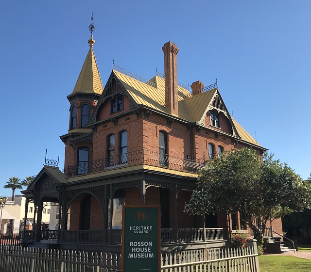
National Register of Historic Places #1971000112
Arizona Historical Marker

See this location on Yahoo Maps in Flickr
See this location on Google Maps

This historic place is located at 139 North 6th Street, Phoenix, Phoenix in the county of Maricopa, Arizona. The GPS coordinates for this location are N 33° 27.001 W 112° 03.962.

You can log your visit to this landmark at waymark.com.

Rosson House

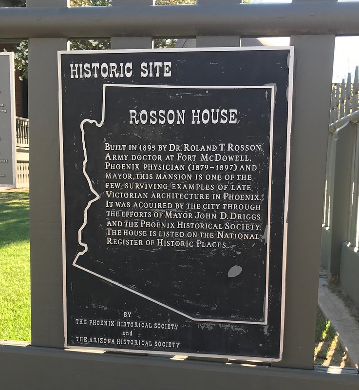
Built in 1895 by Dr. Roland T. Rosson, Army doctor at Fort McDowell. Phoenix physician (1879-1892) and mayor. This mansion is one of the few surviving examples of late Victorian architecture in Phoenix. It was acquired by the city through the efforts of Mayor John D. Driggs and the Phoenix Historical Society. The house is listed on the National Register of Historic Places.

By the Phoenix Historical Society and the Arizona Historical Society


Rosson House

Thursday, March 24, 2011

Scottsdale Grammar School

I wandered by these waymarks as we were winding our way back to buca di beppo after the Giants game.

Scottsdale Grammar School
National Register of Historic Places #1994000571
Arizona Historical Marker

See this location on Yahoo Maps in Flickr
See this location on Google Maps

This historic place is located at 7333 E. Scottsdale Mall, Scottsdale in the county of Maricopa, Arizona. The GPS coordinates for this location are N 33° 29.580 W 111° 55.416.

You can log your visit to this landmark at waymark.com.

Arizona Historical Marker - Scottsdale Grammar School

Dedicated February 26, 1910
on the 73rd birthday of Scottsdale's Founder

CHAPLAIN WINFIELD SCOTT

The building served the
people of Scottsdale as

SCHOOL
COMMUNITY CENTER
CITY HALL AND JUSTICE COURT
LIBRARY

rededicated in 1976
as a building on the State
Register of Historic Places

This plaque donated by the school children of Scottsdale


Scottsdale Historical Museum


Tuesday, April 13, 2010

Father Edouard Gerard

Jack and I stopped at this waymark on day one of this year's Spring Training trip.

Father Edouard Gerard
Arizona Historical Marker

See this location on Yahoo Maps in Flickr
See this location on Google Maps

This marker is located at 231 North 3rd Street in Phoenix, Arizona. The GPS coordinates for this location are N 33° 27.030 W 112° 04.159.

You can log your visit to this landmark at waymark.com.

Arizona Historical Marker - Father Edouard Gerard


Founder, first Catholic church in Phoenix, 1881 - The first priest ordained in Arizona, Father Edouard Gerard, attended the Catholic people of Phoenix from Florence, Arizona, where he was the pastor of the Church of the Assumption from 1877 to 1885. For many years, Father Gerard was Vicar General of the Vicariate Apostolic and Diocese of Tucson. In recognition of his service to the Church, he was named Domestic Prelate by Pope Pius XI. This devoted French missionary died in Prescott, on Christmas Day, 1936, and is buried in Holy Hope Cemetery in Tucson.

St. Mary's

Monday, March 23, 2009

Frenchy Sawyer

S. (Frenchy) Sawyer
Arizona Historical Marker

See this location on Yahoo Maps in Flickr
See this location on Google Maps

This marker is located at the southeast corner of 24th and Washington Streets in Phoenix, Arizona. The GPS coordinates for this location are N 33° 26.890 W 112° 01.750.

You can log your visit to this landmark at waymark.com.


At this site in the Spring of 1868 S. (Frenchy) Sawyer built the first farm dwelling and harvested the first cultivated crop (barley) in the Anglo-American occupation of the Salt River Valley. These same fertile acres ahd been irrigated centuries before by Indians who later abandoned their Canals and Lands.


Monday, March 24, 2008

Site of Hayden's Ferry

Site of Hayden's Ferry
Arizona Historical Marker

See this location on Yahoo Maps in Flickr
See this location on Google Maps

This marker is located at 3 West 1st Street in Tempe, Arizona. The GPS coordinates for this location are N 33° 25.763 W 111° 56.413.

You can log your visit to this landmark at waymark.com.


Site of Hayden's Ferry

200 feet northeast of this marker

Established in 1871 when the Salt River was a flowing stream and a barrier to travel, the ferry was held on course by a wire cable taut across the river. It was an important link in settling the Southwest.

Built and operated by Charles Trumbull Hayden who established the first flour mill in the Salt River Valley.

La Casa Vieja built in 1871 was the Hayden home.

Placed by Arizona Society
Daughters of the American Revolution
1964