Showing posts with label Nevada Historical Marker. Show all posts

Tuesday, August 22, 2017

Nevada Historical Landmark #121

Wandering home from the Petersen Shootout, I made a circuit around the Carson Valley stopping at a number of Nevada Historical Markers, including: Luther Canyon (Fay Canyon) [#118]; Walley's Hot Springs [#120]; Pottsville [#121]; Sheridan [#122]; Boyd Toll Road [#124]; Gardnerville [#129]; Minden [#130], and; Dresslerville [#131].

Mottsville
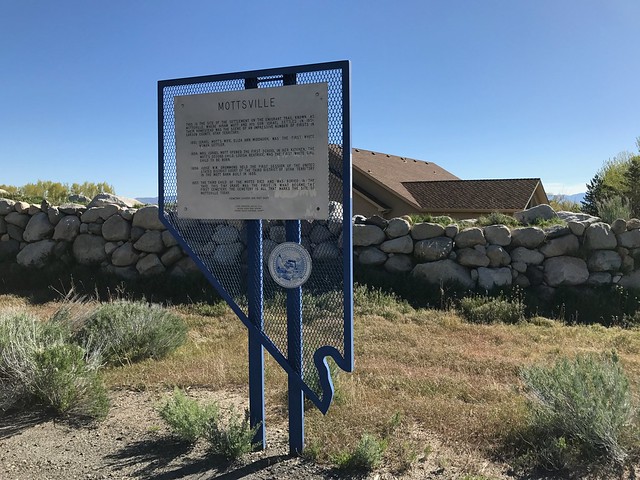
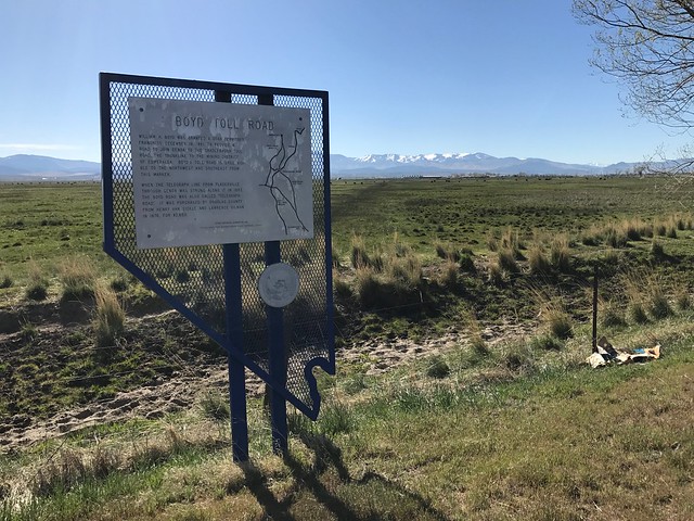
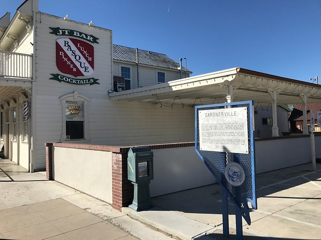
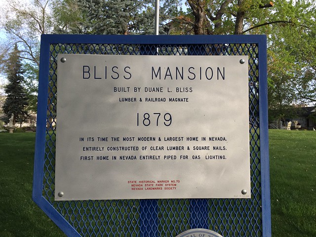
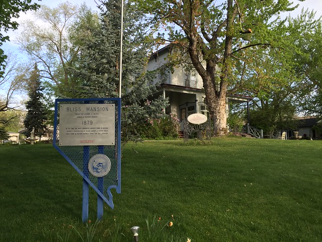
Nevada Historical Marker #121

See this location on Yahoo Maps in Flickr
See this location on Google Maps

This marker is located at 1277 Foothill Road, Gardnerville, Douglas County, Nevada. There are 17 other historical markers in Douglas County. The GPS coordinates for this location are 38° 55' 52.1" N 119° 50' 24.2" W.

Nevada Historical Landmark #121

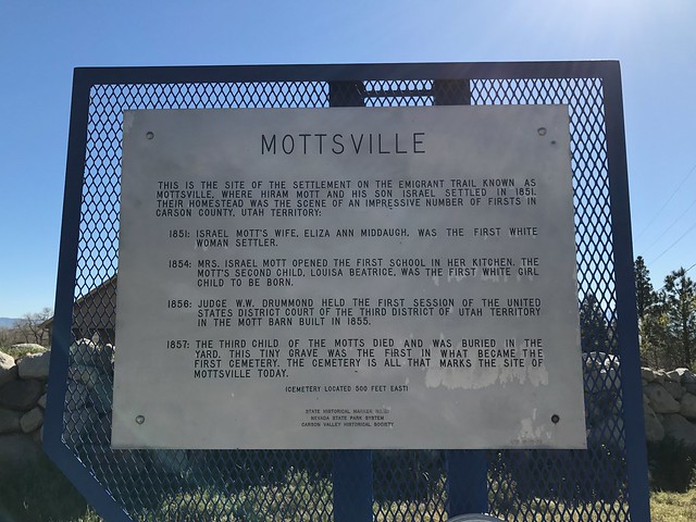
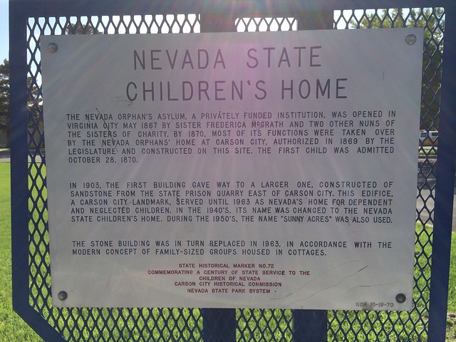
This is the site of the settlement on the Emigrant Trail known as Mottsville, where Hiram Mott and his son Israel settled in 1851. Their homestead was the scene of an impressive number of firsts in Carson County, Utah Territory:

1851: Israel Mott's wife, Eliza Ann Middaugh, was the first white woman settler.

1854: Mrs. Israel Mott opened the first school in her kitchen. The Mott's second child, Louisa Beatrice, was the first white girl child to be born.

1856: Judge W.W. Drummond held the first session of the United States District Court of the Third District of Utah Territory in the Mott barn built in 1855.

1857: The third child of the Motts died and was buried in the yard. This tiny grave was the first in what became the first cemetery. The cemetery, 300 feet east, is all that marks the site of Mottsville today.


Nevada Historical Landmark #121

Tuesday, July 25, 2017

Nevada Historical Landmark #120

Wandering home from the Petersen Shootout, I made a circuit around the Carson Valley stopping at a number of Nevada Historical Markers, including: Luther Canyon (Fay Canyon) [#118]; Walley's Hot Springs [#120]; Pottsville [#121]; Sheridan [#122]; Boyd Toll Road [#124]; Gardnerville [#129]; Minden [#130], and; Dresslerville [#131].

Walley's Hot Springs
Nevada Historical Marker #120

See this location on Yahoo Maps in Flickr
See this location on Google Maps

This marker is located at 2001 Foothill Road, Genoa, Douglas County, Nevada. There are 17 other historical markers in Douglas County. The GPS coordinates for this location are 38° 58' 50.6" N 119° 50' 00.6" W.

Nevada Historical Landmark #120

Like many Nevada hot springs, these dot a fault break along which the mountains rise.

In 1862, along this Carson branch of the Emigrant Trail, David and Harriet Walley developed a $100,000 spa with 11 baths, a ballroom, and gardens. The thermal waters 1136 to 160 degrees Fahrenheit became well known as a cure of "Rheumatism and Scrofulous affections.

It sold for a mere $5,000 in 1896, but functioned as a hotel until 1935 when it burned. Its cool cellar you see is still in use.

In 1962, trial hydro-thermal power holes were drilled here as deep as 1,250': maximum temperature 181 degrees Fahrenheit.


Nevada Historical Landmark #120

Tuesday, June 27, 2017

Nevada Historical Marker #118

Wandering home from the Petersen Shootout, I made a circuit around the Carson Valley stopping at a number of Nevada Historical Markers, including: Luther Canyon (Fay Canyon) [#118]; Walley's Hot Springs [#120]; Pottsville [#121]; Sheridan [#122]; Boyd Toll Road [#124]; Gardnerville [#129]; Minden [#130], and; Dresslerville [#131].

Luther Canyon
Nevada Historical Marker #118

See this location on Yahoo Maps in Flickr
See this location on Google Maps

This marker is located at 445 NV-206, Gardnerville, Douglas County, Nevada. There are 17 other historical markers in Douglas County. The GPS coordinates for this location are 38° 52' 13.7" N 119° 48' 33.8" W.

Nevada Historical Landmark #118

Luther Canyon, west of this site, takes its name from Ira M. Luther, who from 1858-1865 had a sawmill there. The house across the road (east) was his home. After 1865, the canyon came to be known as Horse Thief Canyon, because of the "business" of John and Lute Olds, owners of the next ranch south. Besides operating a station along the Emigrant Trail for a number of years, they rustled horses from emigrants. The animals were sent up the canyon to drift over the ridge into Horse Thief Meadows; after resting and feeding, the horses were driven down to Woodfords Canyon to sell to other emigrants. A prospector called Saw Tooth was allegedly murdered and buried in the barn south of the Luther house. Sam Brown, a notorious badman, was shot and killed in front of the Olds barn in 1861 by a man he threatened. "Lucky Bill" Thorington, implicated in a murder in California, for which he was hanged by vigilantes in 1858, had a ranch two and a half miles to the south--and the pioneers called the school district "Fairview."

Nevada Historical Landmark #118

Friday, June 16, 2017

Nevada Historical Marker #122

Wandering home from the Petersen Shootout, I made a circuit around the Carson Valley stopping at a number of Nevada Historical Markers, including: Luther Canyon (Fay Canyon) [#118]; Walley's Hot Springs [#120]; Pottsville [#121]; Sheridan [#122]; Boyd Toll Road [#124]; Gardnerville [#129]; Minden [#130], and; Dresslerville [#131].

Sheridan
Nevada Historical Marker #122

See this location on Yahoo Maps in Flickr
See this location on Google Maps

This marker is located at 879 Foothill Roard, Gardnerville, Douglas County, Nevada. There are 17 other historical markers in Douglas County. The GPS coordinates for this location are 38° 54' 04.6" N 119° 49' 33.2" W.

Nevada Historical Marker #122

In 1861, a blacksmith shop, a store, a boarding house, and two saloons comprised the village of Sheridan. The village had grown up around Moses Job's General Store prior to 1855.

The surveyor general, in his 1889-90 biennial report, stated that Sheridan was the metropolis of the Carson River West Fork farmers.

The Sheridan House, erstwhile boarding adobe, has been converted to a dwelling. It may be seen across the road. It is all that remains of the "metropolis."

Moses Job, an irrepressible man, climbed the peak above you, planted the American flag and with a shout named the peak after himself! You are looking into Job's Canyon, to its left is Job's Peak, to its right is Job's Sister.


Nevada Historical Marker #122

Monday, June 05, 2017

Nevada Historical Marker #124

Wandering home from the Petersen Shootout, I made a circuit around the Carson Valley stopping at a number of Nevada Historical Markers, including: Luther Canyon (Fay Canyon) [#118]; Walley's Hot Springs [#120]; Pottsville [#121]; Sheridan [#122]; Boyd Toll Road [#124]; Gardnerville [#129]; Minden [#130], and; Dresslerville [#131].

Boyd Toll Road
Nevada Historical Marker #124

See this location on Yahoo Maps in Flickr
See this location on Google Maps

This marker is located at 2153 US-395 Minden, Douglas County, Nevada. There are 17 other historical markers in Douglas County. The GPS coordinates for this location are 38° 59' 18.2" N 119° 46' 45.0" W.

Nevada Historical Marker #142

William H. Boyd was granted a Utah Territory Franchise December 19, 1861, to provide a road to join Genoa to the Cradlebaugh Toll Road, the trunkline to the mining district of Esmeralda. Boyd's Toll Road is still visible to the northwest and southeast from this marker.

When the telegraph line from Placerville through Genoa was strung along it in 1863, the Boyd Road was also called "Telegraph Road." It was purchased by Douglas County from Henry Van Sickle and Lawrence Gilman in 1876 for $2,650.


Nevada Historical Marker #142

Monday, May 22, 2017

Nevada Historical Marker #131

Wandering home from the Petersen Shootout, I made a circuit around the Carson Valley stopping at a number of Nevada Historical Markers, including: Luther Canyon (Fay Canyon) [#118]; Walley's Hot Springs [#120]; Pottsville [#121]; Sheridan [#122]; Boyd Toll Road [#124]; Gardnerville [#129]; Minden [#130], and; Dresslerville [#131].

Dresslerville
Nevada Historical Marker #131

See this location on Yahoo Maps in Flickr
See this location on Google Maps

This marker is located at 892 US Hwy 395 N, Gardnerville, Douglas County, Nevada. There are 17 other historical markers in Douglas County. The GPS coordinates for this location are 38° 54' 14.9" N 119° 42' 21.4" W.

Nevada Historical Marker #131

In 1917 State Senator William F. Dressler gave this 40-acre tract to Washo Indians, then living on ranches in Carson Valley. After a school was opened in 1924, it became a nucleus of settlement.

Before the intrusion of Caucasians in 1848, Washo lived in winter in the Pinenut Hills where they stored autumn harvested pinenuts. In summer, they lived in the Lake Tahoe Basin fishing the tributary streams and gathering roots and berries. In fall, they hunted jackrabbits and gathered seeds in Carson Valley.

Their only form of organization was that of kinship.

These stone age people lived in daily communion with giants, monsters, animals whose characteristics were interchangeable with those of people, and with water babies, "having the bodies of old men and the long hair of girls," who lived in the lakes of the High Sierra.


Nevada Historical Marker #131

Thursday, May 11, 2017

Nevada Historical Marker #129

Wandering home from the Petersen Shootout, I made a circuit around the Carson Valley stopping at a number of Nevada Historical Markers, including: Luther Canyon (Fay Canyon) [#118]; Walley's Hot Springs [#120]; Pottsville [#121]; Sheridan [#122]; Boyd Toll Road [#124]; Gardnerville [#129]; Minden [#130], and; Dresslerville [#131].

Gardnerville
Nevada Historical Marker #129

See this location on Yahoo Maps in Flickr
See this location on Google Maps

This marker is located at 1430 US Hwy 395 N, Gardnerville, Douglas County, Nevada. There are 17 other historical markers in Douglas County. The GPS coordinates for this location are 38° 56' 26.7" N 119° 44' 55.8" W.

Nevada Historical Marker #129

Early Gardnerville served the farming community and teamsters hauling local produce to booming Bodie. The first buildings were a blacksmith shop, a saloon and the Gardnerville Hotel. The latter was moved by Lawrence Gilman in 1879 from the emigrant trail between Genoa and Walley's Hot Springs, where it was known as Kent House, to this site, the homestead of John M. Gardner.

Just as Genoa was the center for British settlers (largely Mormon) after 1851, so Gardnerville, after 1879, became the center for 1870 Danish immigrants. They founded the Valhalla Society in 1885 and met in Valhalla Hall--now gone.

Starting in 1898, Spanish and French Basque shepherds tended some 13,000 sheep in Carson Valley, increasing to 25,000 by 1925, when the Basques began acquiring their own sheep and land. After 1918, several Basques in Gardnerville opened inns which flourished during the Prohibition years.


Nevada Historical Marker #129

Wednesday, May 03, 2017

Nevada Historical Marker #130

Wandering home from the Petersen Shootout, I made a circuit around the Carson Valley stopping at a number of Nevada Historical Markers, including: Luther Canyon (Fay Canyon) [#118]; Walley's Hot Springs [#120]; Pottsville [#121]; Sheridan [#122]; Boyd Toll Road [#124]; Gardnerville [#129]; Minden [#130], and; Dresslerville [#131].

Minden
Nevada Historical Marker #130

See this location on Yahoo Maps in Flickr
See this location on Google Maps

This marker is located at 1599 Highway 395 N, Minden, Douglas County, Nevada. There are 17 other historical markers in Douglas County. The GPS coordinates for this location are 38° 57'09.9" N 119° 45' 42.8"W.

Nevada Historical Marker #130

Minden, the seat of Douglas County since 1916, was named for a town in Westphalia, Germany, where the founder of the H.F. Dangberg Land and Live Stock Company was born in 1829. The company established Minden in 1905 to provide terminal facilities for the Virginia and Truckee Railroad, which was then extending a branch line southward from Carson City. The passenger and freight depot was situated at this point.

Principal promoter of the town and its related development was H.F. Dangberg, Jr., secretary of the company and son of the founder.


Nevada Historical Marker #130

Monday, June 06, 2016

Nevada Historical Landmark #175

On my way home from this year's Petersen Shootout, I stopped at six Nevada State Historical Markers, including Bliss Mansion [#70], Methodist Church of Carson City [#71], Orion Clemens' Home [#78], Stewart-Nye Residence [#175], Rinckel Mansion [#252] and The Governor's Mansion [#259].

Stewart-Nye Residence
Nevada Historical Marker #175

See this location on Yahoo Maps in Flickr
See this location on Google Maps

This marker is located at 108 North Minnesota Street, Carson City, Nevada. There are 25 other historical markers in Carson City County. The GPS coordinates for this location are N 39° 09.840 W 119° 46.238.

You can log your visit to this landmark at waymark.com.

Nevada Historical Landmark #175

This house was built about 1860 of local sandstone for William Morris Stewart who lived here until 1862. He sold it to the territorial governor of Nevada, James W. Nye. The two men were elected as Nevada’s first United States senators after the territory achieved statehood in 1864. Stewart served from 1864 to1875 and again from 1887 to 1905. Nye served from 1864 to 1873. Both men were originally from New York.

The house later became the home of Nevada Supreme Court Chief Justice George F. Talbot. In 1917 he sold the house and block to the Catholic diocese and it served as the rectory for the Catholic Church. It was subsequently sold for commercial use.


Nevada Historical Landmark #175

Nevada Historical Landmark #175

Wednesday, June 01, 2016

Nevada Historical Landmark #78

On my way home from this year's Petersen Shootout, I stopped at six Nevada State Historical Markers, including Bliss Mansion [#70], Methodist Church of Carson City [#71], Orion Clemens' Home [#78], Stewart-Nye Residence [#175], Rinckel Mansion [#252] and The Governor's Mansion [#259].

Orion Clemens' Home
Nevada Historical Marker #78

See this location on Yahoo Maps in Flickr
See this location on Google Maps

This marker is located at 512 North Division Street, Carson City, Nevada. There are 25 other historical markers in Carson City County. The GPS coordinates for this location are N 39° 09.997 W 119° 46.175.

You can log your visit to this landmark at waymark.com.

Nevada Historical Marker #78

Orion Clemens, secretary to Territorial Governor James W. Nye, lived in this house with his wife, "Mollie," from 1864 to 1866. His brother, Samuel, a reporter for the Territorial Enterprise, who later became famous as "Mark Twain," stayed here periodically in 1864.

Nevada Historical Marker #78

Wednesday, May 18, 2016

Nevada Historical Marker #252

On my way home from this year's Petersen Shootout, I stopped at six Nevada State Historical Markers, including Bliss Mansion [#70], Methodist Church of Carson City [#71], Orion Clemens' Home [#78], Stewart-Nye Residence [#175], Rinckel Mansion [#252] and The Governor's Mansion [#259].

Rinckel Mansion
Nevada Historical Marker #252

See this location on Yahoo Maps in Flickr
See this location on Google Maps

This marker is located at 112 North Curry Street, Carson City, Nevada. There are 25 other historical markers in Carson City County. The GPS coordinates for this location are N 39° 09.845 W 119° 46.079.

You can log your visit to this landmark at waymark.com.

Nevada State Historical Landmark #252

Completed in 1876, this palatial residence is an excellent example of High Victorian Italianate architecture in Carson City. Charles H. Jones, a French-schooled designer, constructed the residence for Mathias Rinckel using European craftsmen. The mansion is constructed of pressed brick resting upon a sandstone ashlar foundation. The sandstone originated from the Nevada State Prison quarry. The brick came from Carson Valley and knot-free lumber was obtained from the pine forests of Lake Tahoe.

Rinckel, a German immigrant and pioneer Carson City merchant, accumulated a degree of wealth in the gold fields in the Feather River District of California from 1849 to 1859. He increased his fortune in mining at Virginia City during that city’s infancy. In 1863, Rinckel settled in Carson City, where he engaged in raising livestock and butchering. As a successful merchant, he supplied the mining and timber districts surrounding Eagle Valley with meat.


Nevada Historical Landmark #252

Wednesday, May 11, 2016

Nevada Historical Marker #71

On my way home from this year's Petersen Shootout, I stopped at six Nevada State Historical Markers, including Bliss Mansion [#70], Methodist Church of Carson City [#71], Orion Clemens' Home [#78], Stewart-Nye Residence [#175], Rinckel Mansion [#252] and The Governor's Mansion [#259].

Methodist Church of Carson City
Nevada Historical Marker #71

See this location on Yahoo Maps in Flickr
See this location on Google Maps

This marker is located at 212 North Division Street, Carson City, Nevada. There are 25 other historical markers in Carson City County. The GPS coordinates for this location are N 39° 09.882 W 119° 46.181.

You can log your visit to this landmark at waymark.com.

Nevada Historical Marker #71

Dedicated in 1867, this church serves a congregation that was organized in 1859 and is often referred to as the "Cradle of Nevada Methodism." Like many other buildings in Carson City, the stone used in its construction was quarried at the nearby State Prison. Reverend Warren Nims (Pastor 1863-1866) was responsible for much of the original construction. Altered extensively over the years, the structure with its octagonal porch posts and pointed-arch windows is still an excellent local example of the Gothic Revival style.

Nevada Historical Marker #71

Monday, May 02, 2016

Nevada Historical Marker #70

On my way home from this year's Petersen Shootout, I stopped at six Nevada State Historical Markers, including Bliss Mansion [#70], Methodist Church of Carson City [#71], Orion Clemens' Home [#78], Stewart-Nye Residence [#175], Rinckel Mansion [#252] and The Governor's Mansion [#259].

Bliss Mansion
Nevada Historical Marker #70

See this location on Yahoo Maps in Flickr
See this location on Google Maps

This marker is located at 608 Elizabeth Street, Carson City, Nevada. There are 25 other historical markers in Carson City County. The GPS coordinates for this location are N 39° 10.034 W 119° 46.328.

You can log your visit to this landmark at waymark.com.

Nevada Historical Marker #70

Built by Duane L. Bliss
Lumber & Railroad Magnate
1879
In its time the most modern & largest home in Nevada. Entirely constructed of
clear lumber & square nails. First home in Nevada entirely piped for gas lighting.

Nevada Historical Marker #70

Wednesday, April 27, 2016

Nevada Historical Marker #259

On my way home from this year's Petersen Shootout, I stopped at six Nevada State Historical Markers, including Bliss Mansion [#70], Methodist Church of Carson City [#71], Orion Clemens' Home [#78], Stewart-Nye Residence [#175], Rinckel Mansion [#252] and The Governor's Mansion [#259].

The Governor's Mansion
Nevada Historical Marker #259

See this location on Yahoo Maps in Flickr
See this location on Google Maps

This marker is located at 606 Mountain Street, Carson City, Nevada. There are 25 other historical markers in Carson City County. The GPS coordinates for this location are N 39° 10.036 W 119° 46.379.

You can log your visit to this landmark at waymark.com.

Nevada State Historical Marker #259

Reno architect George A. Ferris designed this neo-classical mansion, which cost $22,700. It is the only home ever built for Nevada's highest elected official. In July 1909, Acting Governor Denver Dickerson and his wife Una became the first residents of the mansion. Two months later, June Dickerson was born here.

From 1909 to 1999, sixteen families have occupied the Mansion. In 2000, First Lady Dema Guinn began a revitalization of the grounds. Private funds supported many of the improvements, including this fence extension donated by Steel Engineers, Inc., Las Vegas and Blue Mountain Steel, Inc., Carson City.


Untitled

Tuesday, May 12, 2015

Nevada Historical Marker #72

I stopped here on my way home from last year's Petersen Shootout.

Nevada State Children's Home
Nevada Historical Marker #72

See this location on Yahoo Maps in Flickr
See this location on Google Maps

This marker is located at 673 South Stewart Street, Carson City, Nevada. There are 25 other historical markers in Carson City County. The GPS coordinates for this location are N 38° 57.930 W 119° 50.390.

You can log your visit to this landmark at waymark.com.

Nevada Historical Marker #72


The Nevada Orphan's Asylum, a privately funded institution, was opened in Virginia City in May, 1867, by Sister Frederica McGrath and two other nuns of the Sisters of Charity. By 1870, most of its functions were taken over by the Nevada Orphans' Home at Carson City, authorized in 1869 by the Legislature and constructed on this site. The first child was admitted October 28, 1870.

In 1903, the first building gave way to a larger one, constructed of sandstone from the state prison quarry east of Carson City. This edifice, a Carson City landmark, served until 1963 as Nevada's home for dependent and neglected children. In the 1940's, its name was changed to the Nevada State Children's Home. During the 1950's, the name "Sunny Acres" was also used.

The stone building was in turn replaced in 1963, in accordance with the modern concept of family- sized groups housed in cottages.


Nevada Historical Marker #72

Friday, September 14, 2012

Nevada Historical Marker #191

On the way to the first day of the Petersen Shoot-out golf tournament in Reno in April, I stopped at two Nevada historical markers: The Great Train Robbery [#128] and Verdi [#191].

Verdi
Nevada Historical Marker #191

See this location on Yahoo Maps in Flickr
See this location on Google Maps

This marker is located Along 3rd Street/Old US 40 (SR 425) near Crystal Peak Park, Verdi, Nevada. There are 41 other historical markers in Washoe County. The GPS coordinates for this location are N 39° 30.953 W 119° 59.634.

You can log your visit to this landmark at waymark.com.

Nevada Historical Marker #191

Modern Verdi came into being with the construction of the Central Pacific Railroad through Nevada in 1867-69. It became a major mill town and terminal for the shipment of ties and construction timbers, with a network of logging railways reaching into the timber north and west of here.

In 1860, a log bridge was built across the Truckee River near where Verdi is now located. Known as O'Neil's Crossing, the site served as a stage stop during the 1860's on the heavily traveled Henness Pass turnpike and Toll Road and the Dutch flat and Donner Lake Road.

In 1864, the Crystal Peak Company laid out a town on the site some two milesfrom Verdi's present location. The company owned mining and lumbering interests near the settlement which was then called Crystal Peak.

Verdi remained an active lumbering center into the twentieth century due to the exertions of men like Oliver Lonkey of the Verdi Lumber Company. A disastrous fire in 1926, plus depletion of timber reserves, resulted in Verdi's decline.


Nevada Historical Marker #191

Friday, August 03, 2012

Nevada Historical Marker #128

On the way to the first day of the Petersen Shoot-out golf tournament in Reno in April, I stopped at two Nevada historical markers: The Great Train Robbery [#128] and Verdi [#191].

The Great Train Robbery
Nevada Historical Marker #128

See this location on Yahoo Maps in Flickr
See this location on Google Maps

This marker is located at the intersection of Bridge Street and South Verdi Road, Verdi, Nevada. There are 41 other historical markers in Washoe County. The GPS coordinates for this location are N 39° 31.047 W 119° 59.307.

You can log your visit to this landmark at waymark.com.

Nevada Historical Marker #128

The West's first train robbery occurred near this site on the night of November 4, 1870. Five men, led by a stage robber, Sunday School superintendent John Chapman, boarded the Central Pacific Overland Express at Verdi, Nevada. Two took over the engine, one the express car, and two the rear platform. One-half mile east, the engine and express car were halted and cut free, then proceeded about five miles, where they were stopped by a barricade. Here the robbers forced the messenger to open up. Seizing $41,600 in gold coin, they rode off. The uncoupled cars coasted downgrade and met the engine. The train proceeded to Reno. After a two-state chase, all were caught, tried and convicted. About 90 per cent of the gold was recovered.

Nevada Historical Marker #128

Saturday, July 14, 2012

Nevada Historical Marker #7

Wandering home after this year's Petersen Shootout, this is one of the places I stopped. I visited five Nevada State historical markers [Buckland's Station #192, Camels in Dayton #199, Halls Station #200, Chinatown #163 and Dayton #7] and three Pony Express Markers [Nevada Station, Dayton and Fort Churchill] and wandered through the Fort Churchill ruins.

Dayton
Nevada Historical Marker #7

See this location on Yahoo Maps in Flickr
See this location on Google Maps

This landmark is located at the southeast corner of Highway 50 and Dayton Valley Road in Dayton, Nevada. There are 18 other historical markers in Lyon County. The GPS coordinates for this location are N 39° 14.173 W 119° 35.358.

You can log your visit to this landmark at waymark.com.

Nevada Historical Marker #7

Dayton, one of the earliest settlements in Nevada was first known as a stopping place on the river for California-bound pioneers. Coming in from the desert they rested here before continuing westward.

In 1849, gold was found at the mouth of Gold Canyon and prospecting began in the canyons to the west. This led to the discovery of the fabulous ore deposits at Gold Hill and Virginia City in 1859.

Called by several different names in its early years, the place became Dayton in 1861, named in honor of John Day who laid out the town.

For many decades Dayton prospered as a mill and trading center and remained the county seat for Lyon County until 1911.


Nevada Historical Marker #7

Wednesday, June 20, 2012

Nevada Historical Marker #163

Wandering home after this year's Petersen Shootout, this is one of the places I stopped. I visited five Nevada State historical markers [Buckland's Station #192, Camels in Dayton #199, Halls Station #200, Chinatown #163 and Dayton #7] and three Pony Express Markers [Nevada Station, Dayton and Fort Churchill] and wandered through the Fort Churchill ruins.

Chinatown
Nevada Historical Marker #163

See this location on Yahoo Maps in Flickr
See this location on Google Maps

This landmark is located at the southeast corner of Highway 50 and Dayton Valley Road in Dayton, Nevada. There are 18 other historical markers in Lyon County. The GPS coordinates for this location are N 39° 14.175 W 119° 35.357.

You can log your visit to this landmark at waymark.com.

Nevada Historical Marker #163

Chinatown
Early Name of Dayton

The first Chinese were brought to this site in 1856 to build the "Reese" ditch from the Carson River to the entrance of Gold Canyon. The ditch was used for placer mining. The Chinese soon began reworking the placers. Earning a living from those abandoned by the miners, so many Chinese followed (200) that the settlement was called Chinatown. The name was changed to Dayton in 1861 in honor of John Day, who laid out the town and later became General of Nevada.

State Historical Marker No. 163
Nevada State Park System
Dayton Historical Society

Nevada Historical Marker #163

Friday, June 08, 2012

Nevada Historical Marker #200

Wandering home after this year's Petersen Shootout, this is one of the places I stopped. I visited five Nevada State historical markers [Buckland's Station #192, Camels in Dayton #199, Halls Station #200, Chinatown #163 and Dayton #7] and three Pony Express Markers [Nevada Station, Dayton and Fort Churchill] and wandered through the Fort Churchill ruins.

Hall's Station
Nevada Historical Marker #200
Pony Express Marker

See this location on Yahoo Maps in Flickr
See this location on Google Maps

This landmark is located at 225 Pike Street, Dayton, Nevada. There are 18 other historical markers in Lyon County. The GPS coordinates for this location are N 39° 14.149 W 119° 35.548.

A list of Pony Express Waymarks that I have visited can be found here. You can log your visit to this landmark at waymark.com.

Spafford Hall's Station was the first Pony Express stop in Dayton. The Union Hotel now occupies the second site for the remount station.

Nevada Historical Marker #200

HALL’S STATION

Spafford Hall built this station and trading post in the early 1850s to accommodate emigrants bound for California. Hall, who was the first permanent settler here, was severely injured in a hunting accident in 1854 and sold the station to one of his employees, James McMarlin. It became known as McMarlin’s Station. Major Ormsby bought the station sometime between 1854 and 1860. The title was still in his name in 1860 when he died in the first battle of the Pyramid Lake War.

A special niche in Nevada’s history is accorded this site as the place where the first recorded dance was held on New Year’s Eve, 1853. The exact site was destroyed by an excavation for building materials.

STATE HISTORICAL MARKER No. 200
STATE HISTORIC PRESERVATION OFFICE
DAYTON HISTORICAL SOCIETY

Nevada Historical Marker #200