Wednesday, June 29, 2005

Cisco Executive Briefing Day 2

A group from Sutter spent a second day at the Cisco Executive Briefing Center. The agenda included: Cisco's IP Communications Strategy and Rich Media Solutions; Disaster Recovery and Business Continuity; Technology Innovation Center - IP Communications; Cisco's IP Communications Implementation; and, Real World Experiences, Lessons Learned in Enterprise Scale IP Communications Deployments.

This is the third briefing that we have done in the last eighteen months. We had a wireless briefing in March 2004 and a storage briefing in June 2004. My major conclusion from the two days is that we have to get our QOS project off the ground.

Tuesday, June 28, 2005

Cisco Executive Briefing Day 1

A large group from Sutter Health including Larkin, Wike, Jugoz, Risch and I spent the day at the Cisco Systems Executive Briefing Center in San Jose. The agenda topics included: Self Defending Network Initiative; Cisco Leadership in Healthcare; Security Management, and; Cisco Security Best Practices.

Google Earth

Google has released Google Earth; this is a very, very cool piece of software. I have had a chance to use it a little today and I am very impressed.

Once you have downloaded and installed the software, you can load my pictures of the Pony Express Stops from the Pleasant Grove to Friday's Station. You can use the tilt and other features to get a good idea of the terrain.

Monday, June 27, 2005

2005 Best Places To Work in IT

For the 3rd Year in a row, Sutter Health System Support (SHSS) Information Technology has been rated as one of the top 100 places to work for IT professionals.

Out of the top 100, Sutter Health ranked 12th!

This is up from 34th in 2004.

This is up from 64th in 2003.

The honor is part of the weekly newspaper Computerworld's 12th annual Best Places to Work in IT survey, which ranks the top 100 work environments for technology professionals using the categories of benefits, diversity, career development, training and retention.

Sunday, June 26, 2005

Heading Home

After finding one more Pony Express Stop in Stateline, Jack and I had breakfast at IHOP and then started for home. Sharon caught an early flight from Boston to Chicago and then Chicago to Sacramento and was home in the middle of the afternoon.

Sharon and Jack spent the afternoon watching watching Star Wars - Episode II, Attack of the Clones on DVD.

California Historical Landmark #728

Pony Express Friday's Station
California State Historical Landmark #728

See this location on Yahoo Maps in Flickr
See this location on Google Maps

This landmark is located at the Northwest corner of the intersection of Highway 50 and Lake Parkway in Stateline, Nevada. There are 29 other California State Historical Landmarks in El Dorado County. The GPS coordinates for this location are N 38° 57.844 W 119° 56.343.

A list of Pony Express Waymarks that I have visited can be found here. You can log your visit to this site at waymarking.com!


The Pony Express started on April 3, 1860. The original route from Johnson Pass (Echo Summit) to Genoa went over Luther Pass and through Hope Valley to Woodfords Station.

On May 14, 1860, The new toll road over Daggett Pass opened to foot and horse traffic and was now used by the Pony Express through Lake Valley, Known as the Kingsbury Grade and built by David Kingsbury and John McDonald, it was opened to wagon traffic on August 14, 1860.

A new station was needed and "Friday's" Station was used. This 320 acre site was first owned by Martin K. "Friday" Burke and John Washington Small. The station site can still be seen across Highway 50 (the two story wood frame white building). It is 1,070 feet from here on a bearing of sixty degrees true North.

Saturday, June 25, 2005

Pony Express Trail

Starting in Old Sacramento in the morning, Jack and I spent the day following the Pony Express Route from Sacramento to Stateline, Nevada. Along the way, we stopped at all of the California State Historical Landmarks commemorating the remount and relay stations. We checked into the Marriot Grand Residence Club at South Lake Tahoe. After dinner at Cecil's Steak & Brew, we settled in and watched Star Wars - Episode I, The Phantom Menace on DVD.

SAH Boston Day 2

Sharon and Liz spent the morning wandering around Cambridge, including the Harvard campus, the Harvard Law School and the surrounding neighborhoods. In the afternoon, they went to the Isabella Steward Gardner Museum. They finished the day getting pizza for dinner.

Harrah's Monument

Pony Express Monument
Harrah's Casino
See this location on Yahoo Maps in Flickr
See this location on Google Maps

You can log your visit to this site at waymarking.com!


In commemoration of the Pony Express
Fleeting but Exciting Epoch in the winning of the West
Erected April 4th 1963 by Harrah's
William F. Harrah, President

The 1st Pony Express rider passed here April 4th 1860 on his way to Friday's Station, a remount point 4/10ths of a mile Northeast at Edgewood, Nevada.

California Historical Landmark #708

Pony Express Yank's Station
California State Historical Landmark #708

See this location on Yahoo Maps in Flickr
See this location on Google Maps

This landmark is located in the Yank's Station shopping center, on the southwest corner of State Highway 50 and Apache Avenue, Meyers, California. There are 29 other California State Historical Landmarks in El Dorado County. The GPS coordinates for this location are N 38° 51.357 W 120° 00.768.

A list of Pony Express Waymarks that I have visited can be found here. You can log your visit to this site at waymarking.com!


This was the site of the most eastern remount station of the Central Overland Pony Express in California. Established as a trading post in 1851 by Martin Smith, it became a popular hostelry and stagestop operated by Ephraim "Yank" Clement on the Placerville-Carson Road. Pony rider Warren Upson first arrived here on the evening of April 28, 1860. Changing ponies, he galloped on to Friday's in Nevada to deliver his mochila to Bob Haslam for the ride to Genoa. Used as a pony remount station until October 26, 1861, it was sold to George M. Meyers in 1873, and the name changed to Meyers.

California Historical Landmark #707

Pony Express Strawberry Valley House
California State Historical Landmark #707

See this location on Yahoo Maps in Flickr
See this location on Google Maps

This landmark is located at Strawberry on Highway 50 (P.M. 578), 8.7 miles east of Kyburz, California in El Dorado County. There are 29 other California State Historical Landmarks in El Dorado County. The GPS coordinates for this location are N 38° 47.720 W 120° 08.900.

A list of Pony Express Waymarks that I have visited can be found here. You can log your visit to this landmark at waymark.com.


This popular resort and stopping place for stages and teams of the comstock, established by Swift and Watson in 1856, became a remount station of the Central Overland Pony Express on April 4, 1860. Here on that date, division superintendent Bolivar Roberts waited with a string of mules to help pony rider Warren Upson through the snowstrom on Echo Summit.

California Historical Landmark #706

Pony Express Webster's Sugar Loaf House
California State Historical Landmark #706

See this location on Yahoo Maps in Flickr
See this location on Google Maps

This landmark is located on Hwy 50 (P.M. 48. 0), 1.0 mile weest of Kyburz, California in El Dorado County. There are 29 other California State Historical Landmarks in El Dorado County. The GPS coordinates for this location are N 38° 46.204 W 120° 18.754.

A list of Pony Express Waymarks that I have visited can be found here. You can log your visit to this landmark at waymark.com.


This was the site of Webster's Sugar Loaf House, well-known stopping place during the comstock rush. Beginning in April 1860, it was used as a remount station of the Central Overland Pony Express. In 1861, it became a horse change station for Pioneer Stage Companys and Overland Mail.

California Historical Landmark #705

Pony Express Moore's (Riverton)
California State Historical Landmark #705
See this location on Yahoo Maps in Flickr
See this location on Google Maps

This landmark is located at At the intersection of US Highway 50 and Ice House Road (P.M. 39.7), 9.0 miles West of Kyburz, California in El Dorado County. There are 29 other California State Historical Landmarks in El Dorado County. The GPS coordinates for this location are N 38° 46.271 W 120° 26.948.

A list of Pony Express Waymarks that I have visited can be found here. You can log your visit to this landmark at waymark.com.


This was the site of a change station of the Pioneer Stage Company in the 1850's and 1860's. During 1860-1861, the Central Overland Pony Express maintained here the first pony remount station east of Sportsman's Hall.

California Historical Landmark #704

Pony Express Sportman's Hall
California State Historical Landmark #704

See this location on Yahoo Maps in Flickr
See this location on Google Maps

This landmark is located at 5622 Old Pony Express Trail, Cedar Grove, California in El Dorado County. There are 29 other California State Historical Landmarks in El Dorado County. The GPS coordinates for this location are N 38° 45.009 W 120° 36.673.

A list of Pony Express Waymarks that I have visited can be found here. You can log your visit to this landmark at waymark.com.


This was the site of Sportsman's Hall, also known as Twelve-Mile House. The hotel operated in the late 1850's and 1860's by John and James Blair. A stopping point for stages and teams of the comstock, it became a relay station of the Central Overland Pony Express. Here at 7:40 a.m. April 4, 1860, pony rider William (Sam) Hamilton, riding in from Placerville, handed the express mail to Warren Upson, who, two minutes later, sped on this way eastward.

California Historical Landmark #701

Placerville Pony Express Station and Terminus
California State Historical Landmark #701

See this location on Yahoo Maps in Flickr
See this location on Google Maps

This landmark is located at the southwest corner of Main and Sacramento Streets, Placerville, California in El Dorado County. There are 29 other California State Historical Landmarks in El Dorado County. The GPS coordinates for this location are N 38° 43.671 W 120° 48.196.

A list of Pony Express Waymarks that I have visited can be found here. You can log your visit to this landmark at waymark.com.


Gold Rush town and Western Terminus of the Placerville-Carson Road to the Comstock, Placerville was a relay station of the Central Overland Pony Express, April 4, 1860 - June 30, 1861. Here on April 4, 1860, the first east-bound pony rider William (Sam) Hamilton changed horses, added one express letter to the mochila and sped away for Sportsman's Hall. On July 1, 1861, Placerville became the Western Terminus of the Pony Express, until its discontinuance on October 26, 1861.

California Historical Landmark #700

Pony Express El Dorado
California State Historical Landmark #700

See this location on Yahoo Maps in Flickr
See this location on Google Maps

This landmark is located at the southwest corner of Pleasant Valley Road near Church Street, El Dorado, California in El Dorado County. There are 29 other California State Historical Landmarks in El Dorado County. The GPS coordinates for this location are N 38° 40.951 W 120° 50.927.

You can log your visit to this landmark at waymark.com.


Trading Post, emigrant stop and mining camp of the 1850's. This became one of the remount stations of the Central Overland Pony Express. Here at the Nevada House on April 13, 1860, Rider William (Sam) Hamilton changed horses while carrying the first west-bound mail of the pony express from St. Joseph, Missouri, to Sacramento, California.

California Historical Landmark #703

Pony Express Pleasant Grove House
California State Historical Landmark #703

See this location on Yahoo Maps in Flickr
See this location on Google Maps

This landmark is located at the southwest corner of Pleasant Valley Road near Church Street, El Dorado, California in El Dorado County. There are 29 other California State Historical Landmarks in El Dorado County. The GPS coordinates for this location are N 38° 41.876 W 121° 01.225.

A list of Pony Express Waymarks that I have visited can be found here. You can log your visit to this landmark at waymark.com.


This was the site of the a popular roadhouse where the ponies of the Central Overland Pony Express were changed during July 1, 1860 - June 30, 18961. From here the route of the pony riders continued westward to Folsom and eastward through Rescue, Dry Creek Crossing and Missouri Flat to Placerville.

California Historical Landmark #699

Pony Express Mormon Tavern
California State Historical Landmark #699
See this location on Yahoo Maps in Flickr
See this location on Google Maps

This landmark is located on Joerger Cutoff Road in El Dorado Hills, California in El Dorado County. There are 29 other California State Historical Landmarks in El Dorado County. The GPS coordinates for this location are N 38° 39.370 W 121° 03.575.

A list of Pony Express Waymarks that I have visited can be found here. You can log your visit to this landmark at waymark.com.


At this site on the old Clarksville White Rock Emigrant Road was Mormon Tavern. Completed in 1849 and enlarged and operated by Franklin Winchell in 1851. A popular stop for teams and stages, it became a remount station on the Central Overland Pony Express. Here on April 4, 1860, pony rider William (Sam) Hamilton changed horses on the first trip eastward of the pony express.

California Historical Landmark #702

Folsom Pony Express Terminus
California State Historical Landmark #702

See this location on Yahoo Maps in Flickr
See this location on Google Maps

This landmark is located at 819 Sutter Street, Folsom, California. There are 57 other California State Historical Landmarks in Sacramento County. The GPS coordinates for this location are N 38° 40.587 W 121° 10.713.

A list of Pony Express Waymarks that I have visited can be found here. You can log your visit to this landmark at waymark.com.


Gold Rush and Railroad town Folsom became the Western Terminus of the Central Overland Pony Express on July 1, 1860. The express mail had been run by pony to and from Sacramento. Beginning on July 1, 1860, the Sacramento Valley Railroad carried it between Sacramento and Folsom until Placerville was made the Terminus during July 1 - October 26, 1861.

California Historical Landmark #698

Pony Express
Fifteen Mile House
California State Historical Landmark #698

See this location on Yahoo Maps in Flickr
See this location on Google Maps

This landmark is located at the corner of White Rock and Gold Valley Roads, 0.2 mi east of the intersection of Sunrise Boulevard and White Rock Road, Rancho Cordova, California. There are 57 other California State Historical Landmarks in Sacramento County. The GPS coordinates for this location are N 38° 35.391 W 121° 15.712.

A list of Pony Express Waymarks that I have visited can be found here. You can log your visit to this landmark at waymark.com.


Owned and Operated from 1857 as a stage station by Henry E. W. Deterding. This was the site of the second remount station of the Central Overland Pony Express during March-July 1860. Sam (Bill) Hamilton with the first eastward mail of the Pony Express changed Ponies with Mormon Tavern as his next stop.

California Historical Landmark #697

Pony Express
Five Mile House Station
California State Historical Landmark #697
See this location on Yahoo Maps in Flickr
See this location on Google Maps

This landmark is located on the campus of California State University at 6000 "J" Street, Sacramento, California. From "J" street, go South on State University Drive East to the Guy West Bridge over-crossing and plaza. The plaque located in plaza. There are 57 other California State Historical Landmarks in Sacramento County. The GPS coordinates for this location are N 38° 33.694 W 121° 25.333.

A list of Pony Express Waymarks that I have visited can be found here. You can log your visit to this landmark at waymark.com.


Departing at 2:45 a.m. from the Alta Telegraph Co. in Sacramento, Pony Rider Sam (Bill) Hamilton carried the first mail eastward of the Central Overland Pony Express on April 4, 1860. Here, quickly changing poines he sped on to the next stop at fifteen mile station.

Pony Express Monument

Pony Express Monument
Old Sacramento

Log your visit to this site at waymarking.com!
See this location on Yahoo Maps in Flickr
See this location on Google Maps


This statue commemorates the glory of the Pony Express, which started here at 2:48 a.m. on April 4, 1860, when Sam Hamilton galloped into a blinding rainstorm on the first lap of a 1,966-mile trip to St. Joseph, Missouri. During its 18-month existence, its 121 riders and 800 ponies carried 38,000 pieces of mail with the loss of but one pouch. This venture, founded by Russell, Majors and Waddell, ended California's isolation from the rest of the Union.

Friday, June 24, 2005

SAH Boston Day 1

Sharon and Liz spent a long day touring Boston. They spent the morning walking the Freedom Trail. Starting at the Boston Commons, they visited a number of old buildings. They also visited the Trinity Church and the Boston Public Library.

They spent the afternoon at the Boston Museum of Fine Arts. Eventually, they headed out to Fenway Park to get Jack a Johnny Damon jersey!

They finished the day wandering around the Italian section of the city and having dinner in a undistinguished Italian restaurant.

CA Historical Landmark #779

Rockville Stone Chapel
California State Historical Landmark #779

See this location on Yahoo Maps in Flickr
See this location on Google Maps

This landmark is located in the Rockville Cemetery on Suisun Valley Road, 0.2 mile north of Rockville, California. There are 13 other California State Historical Landmarks in Solano County. The GPS coordinates for this location are N 38° 14.829 W 122° 07.273.

You can log your visit to this landmark at waymark.com.


Erected by pioneers of Methodist Episcopal Church South with volunteer labor and donated funds. Cornerstone laid October 3, 1856. Dedicated February 1857. Site supplied by Landy and Sarah Alford. Chapel deteriorated by 1929 and deeded by the church to Rockville Public Cemetery District as a pioneer monument. Restored in 1940.

Thursday, June 23, 2005

SAH to Boston

Sharon spent the morning at the Omega Institute with Liz, including attending an Art Class. After lunch, they rented a car and drove from Rhinebeck, New York to Boston, Massachusetts.

After yesterday's visually stimulating train ride up the Hudson River, Sharon compared the 3 1/2 hour drive from Rhinebeck to Boston to our travels across Florida. She said that it was mile after mile of countryside that looked the same ["kind of boring"].

Sharon and Liz had dinner at McCormick & Schmick's Seafood Restaurant in the Boston Park Plaza Hotel.

Spurs!

Jack and I watched the Spurs beat the Pistons for the NBA Champonship. Watching Duncan go almost 14 minutes without a basket, I was sure that the Spurs were going to collapse like a cheap tent in the second half. They surprised me and hung on to win. Jack announced after the game that he wants a Ginobili Jersey!

11.15 Mile Run

After swinging by the company picnic, I went for a long run. I ended up running 11.15 miles in 1:49:30 for an average pace of 9:50 per mile. I can not remember the last time I ran this far. I used the data from my Garmin Forerunner 201 and the GPSVisualizer web site to generate the following map of the run.


Wednesday, June 22, 2005

SAH Traveling up the Hudson

Wednesday morning, Sharon caught a train at Grand Central Station to Rhinecliff in upstate New York. I talked to her while the train was winding its way up the Hudson River. She raved about the scenery. She was also still raving about Tuesday night's dinner at the Mesa Grill!

At Rhinecliff, she caught a cab to Rhinebeck. Liz has been working at the Omega Institute outside of Rhinebeck for the last couple of months. Sharon is spending Wednesday night at the institute with Liz.

On Tuesday in Manhattan, Sharon also visited McSorley's Old Ale House and one of the T0wer Record stores.

Dinner with Drew

Drew and his friend Mark have been on a road trip for the last few days. Starting from Irvine, they wound their way up the coast and through the bay area. They stopped by on their way to Tahoe and Jack and I had dinner with them at Original Pete's. It was great to see Drew.

Wikitorials

L.A. Times suspends 'Wikitorials'

Flying Spaghetti Monster

The universe was created by a Flying Spaghetti Monster

My Life 1967

1967

click on the picture for a larger copy!
Mark Heringer 1967


My Life

Tuesday, June 21, 2005

SAH in the Village

Sharon is spending Monday and Tuesday night at the Incentra Village House Bed & Breakfast in Greenwich Village. Sharon noted on the phone that she has never had so many women checking her out [hint: Greenwich Village is a big gay and lesbian area].

Tuesday morning, She met Angela and her four month baby boy for breakfast. Angela and Sharon clerked together for the Federal Intermediate Credit Bank of Sacramento in 1986 while they were both in law school.

Originally, Sharon planned to spend part of the day at The Museum of Modern Art, but it is closed on Tuesdays! She ended up spending the day at The Metropolitan Museum of Art. Sharon and I visited both the Met and MoMA plus the Guggenheim when we were in Manhattan in early June of 1998.

Sharon then met Angela sans baby for dinner at Bobby Flay's Mesa Grill. She was very impressed and said it was the best meal that she has eaten in years! This is high praise from someone who is usually very critical.

Monday, June 20, 2005

Ships in the Night

By the time I was in bed Sunday night, it was after 11:00 p.m. Sharon got up at 3:30 a.m. and was out of the door heading for the airport a little after 4:30 a.m. She caught an early morning flight on United to Chicago and then a flight to LaGuardia Airport. She is on a six day east coast swing to visit a couple of friends. She starts with two nights in Greenwich Village in Manhattan.

Drew finished up his sophmore year at the Unversity of California at Irvine and is off on a short road trip. He and a friend are winding their way up the coast. I got a voice message from him from Pismo Beach.

Morgan is off to Iowa City, Iowa for two weeks. She is attending the Iowa Young Writer's Studio at the University of Iowa.

Sunday, June 19, 2005

Washington DC Day 4

After checking out of the hotel, Wallen and I spent the day hanging out at the Nooters and helping them celebrate Father's Day. Morgan called from the Denver Airport, Jack called from home and Drew sent a text message to my phone to wish me happy Father's Day.

We had a leisurely late lunch of barbacued ribs and corn. Wallen and I took off for the airport about 3:00 p.m. I dropped him off at National Airport and headed to Dulles to return the car and catch my flight. It was a very uneventful trip home. The non-stop flight from Dulles back to Sacramento made the trip back very easy.


Saturday, June 18, 2005

Washington DC Day 3

After our run, we caught up with the Nooter's. We loaded up their van and all of us went to Baltimore about an hour drive north. We spent the afternoon wandering around Baltimore's Inner Harbor. We toured the US Submarine Torsk and the US Lightship #116 "Chesapeake." Wallen and I had toured a working Trident submarine with Max in September of 1991. It was interesting to walk through a World War II vintage submarine after having toured a contemporary one. The Torsk seemed tiny compared to my recollections of the multiple decked Trident.

The group then headed to Fells Point and had dinner at Bertha's. Almost everyone, including the kids had a big bowl of mussels.

After dinner, we went to Camden Yards and watched the Baltimore Orioles play the Colorado Rockies. The Orioles won by the score of 7 to 2. Miguel Tejada and Sosa led off the fourth inning with back to back home runs.

After getting home after the game, Nooter, Wallen and I went back to Ireland's Four Provinces Restaurant & Pub for a beer and a long talk about six degrees of separation.

Baltimore versus Colorado


Bertha's Mussels

Baltimore Inner Harbor


moblog Baltimore Inner Harbor

Morning Run DC Day 3

This time, Wallen and I drove to the W&OD Trail. We had a much faster run than the previous day. We covered 7 miles with a per mile pace of 8:10. This is more of a Wallenesque pace. Over the first 4.5 miles, we ran an average pace of 7:58, but slowed down substantially in the last 2.5 miles.

Friday, June 17, 2005

Washington DC Day 2

Wallen and I caught up with Nooter after our run and had a leisurely lunch of Mexican food.

After lunch, we headed out to the National Air and Space Museum's Steven F. Udvar-Hazy Center and spent the afternoon wandering around there. The building is huge; it is 2 1/2 football fields long and 10 stories high. It houses over a 100 aircraft and spacecraft, including the space shuttle Enterprise, an SR-71 Blackbird and the Enola Gay. We finished the day at the museum watching the IMAX film Fighter Pilot: Operation Red Flag.

The adults went out for dinner at a Indian food restaurant called Haandi. It was midnight by the time we were back to the room.

Air and Space Museum pic 1


Air and Space Museum pic 2


Air and Space Museum pic 3


Air and Space Museum pic 4


Air and Space Museum pic 5


Morning Run DC Day 2

After both taking red-eyes on Wednesday night and a late night on Thursday, Wallen and I slept until almost 10 a.m. Wallen and I ran 6.77 miles from the hotel, covering the distance at a pace of 8:52 per mile. This was definitely not a Wallenesque pace; he had run a half marathon the previous weekend and was still feeling the effects a little.

Part of the run was on the W&OD Trail.

Thursday, June 16, 2005

Washington DC Day 1

I flew a red-eye non-stop from Sacramento to Dulles on JetBlue. Wallen and I arrived at Dulles within minutes of each other, picked up our luggage and a rental car. We headed towards the Nooter's house in Falls Church. After a cup of coffee with Rob and Barb, Nooter, Wallen and I went out for a leisurely breakfast at the Pancake House.

After breakfast, Wallen and I headed to Mount Vernon. Both of us have read Washington's biography His Excellency in the last six months. We toured the mansion and wandered around the grounds seeing the gardens, the old tomb, the new tomb, the wharf, the Pioneer Farmer Site and the 16-sided barn.

As we were touring the mansion and coming down the back stairs into Washington's study, Wallen reminded me of the parts in the book talking about how Washington would retreat to his study to get away from all of the visitors. It was a neat connection between the book and the real world.

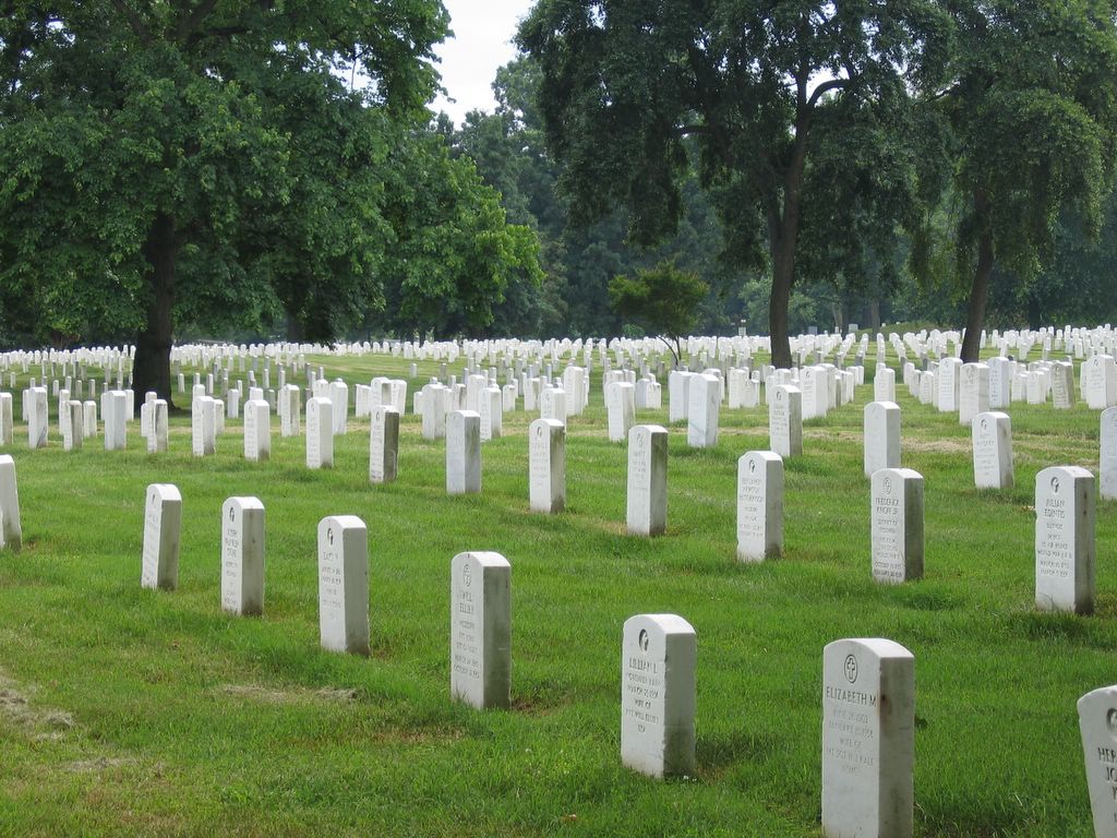
Wallen had suggested on the way to Mount Vernon that we stop at Arlington National Cemetery after Mount Vernon. I was a little skeptical of the idea, but it turned out to be a great stop. Walking through the grounds and looking at the rows of grave markers was more emotional than I had expected. We visited the Tomb of the Unknown Soldier and watched the changing of the guard. We toured the Arlington House and stopped at John F. Kennedy's gravesite.

We met back up with the Nooter's for dinner. We went to Ireland's Four Provinces Restaurant & Pub. I had corn beef and cabbage which was no where as good as Sharon's! In the early years of our relationship, I took Sharon's cooking somewhat for granted. These types of incidents make me realize how good a cook she is.

Mount Vernon


Arlington National Cemetery


JFK Grave